X-PAD Ultimate - Service Pack Updates
The great thing about technology is it's always evolving! GeoMax Positioning are committed to continual development of their survey technology solutions to ensure that customers are provided with the best possible return on their investment. For this reason, we are now able to offer Service Pack Updates for X-PAD Ultimate users, a comprehensive solution that ensures you benefit from all the latest updates and new features!
Service Pack Updates are available for all customers with an up-to-date X-PERT license. For one annual fee you'll receive regular quarterly X-Pad Ultimate updates and access to all the new features as soon as they are released.
AVAILABLE UPDATES & NEW FEATURES
Service Pack 2023 New Features
Advanced Inputs Fields
_Advanced%20Inputs%20Fields.jpg?width=300&height=250&name=1)_Advanced%20Inputs%20Fields.jpg)
These input fields allow the user to calculate and save mathematic formulas, inside the clipboard feature
Base Position Visualization
.jpg?width=300&height=250&name=Base%20Station%20Visualisation%20(1).jpg)
Simply use the maps feature within the GNSS status page to visualize, the base position
Pressure on Sea Level
.jpg?width=299&height=250&name=Presure%20on%20Sea%20level%20(2).jpg)
Activate the corrections and enter the current altitude to calculate the pressure at sea level and current pressure
Service Pack 2022 New Features
Exporting 12D Field File Format
The X-Pad Ultimate can now export even the largest of 12D roading data including all line work, making site design easier than ever before.
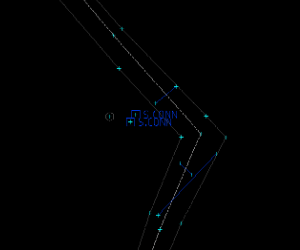
Point Selection By Rule
On Demand Webinar - With the new ‘selection by rules’, available in the List of points, it is now possible to define a rule that automatically selects all matching
points.
Service Pack 2021 New Feature: Pole Adaptor
Why carry two poles when you don't need to?
Designed in New Zealand, this handy new Pole Adapter turns your GNSS Pole into a TPS Pole. This new software feature within X-Pad simply accounts for the height offset.
New Feature: X-PAD 365

One platform, endless service
Constant pressure to deliver excellent results, on time and within budget, is a reality for every surveying and construction professional.
With X-PAD 365, the web-based GeoMax cloud platform, you can manage your data and assets anytime, anywhere, and stay connected with this easy-to-use tool.
Connect to your data anytime, anywhere
Frustrated about not having the right data available
when and where it is needed? X-PAD 365 provides a File Manager giving you one place to store, share and edit your data. The File Manager is a bridge between office and field.
Upgrade your teamwork
Do you want to eliminate the lack of transparent
communication in your team? X-CHAT is an integrated group chat within X-PAD 365, X-PAD Ultimate and X-PAD Fusion. Share your survey and stakeout status, make quick
and reliable decisions together, and support each
other as a team.
Stay current on all your products
Tired of managing loads of documents with product related information? X-PAD 365 serves as an asset management tool where you can register all your equipment. Receive
automatic notifications for your products, making sure you stay up-to-date on all the latest software releases, firmware updates and expiration dates.
New Feature: Free Section
Complete a Free Section using F1 / F2 measurement
Free station calculation is a very important method to calculate the station position and orientation. This process has to be done with extreme accuracy. For this reason, a new option has been created. The new option forces to measure the reference point in direct and reverse face in order to assure maximum accuracy.
Service Pack 2020 New Feature: X-TILT
X-TILT adds tilt functionality to any GeoMax GNSS Receiver! X-TILT is a system that enables users calculate the inclination of a GNSS or a TPS pole. It requires only a fast calibration procedure at the beginning of the activity and then you can start using it.
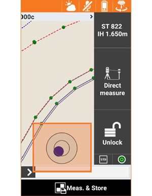
X-TILT Electronic Bubble
X-TILT shows an electronic bubble directly on the main screen allowing to constantly have the tilt status visible. In case of GNSS measurements, epochs are not acquired if the pole is not vertical. This means that you can press the Measure button first and then find the vertical position of the pole.
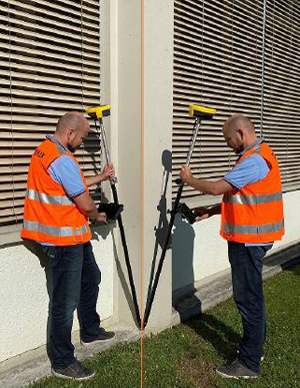
X-TILT Dual tag
A way to measure inaccessible points with GPS using the inclinometer available with GeoMax Zenith 35. With X-TILT, dual tag is extended to all GNSS receiver models.
Dual tag mode requires to measure a point by inclining the pole in two directions and measuring the corresponding position; the position of the point is automatically calculated.
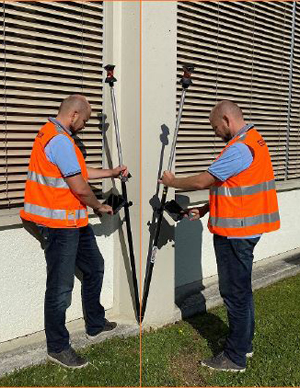
X-TILT TPS Dual tag
Following on from the development of GNSS Dual Tag, we now offer the same solution but for total stations. With X-TILT it is possible to measure an inaccessible point by inclining the pole in two directions and measuring the corresponding position; the position of the point is automatically calculated.
Want the latest features?
Contact us for more information on Service Pack 2 and make sure you get the latest new features like X-TILT now and other important regular X-PAD updates as soon as they are released.
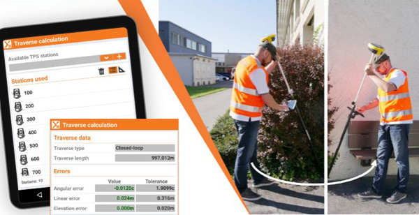
X-TILT takes your surveying to the next level
In this webinar we will share two outstanding features:
- The unique X-TILT feature that has the power to turn every GNSS and TPS pole into a tilt antenna, including e-Bubble.
- The Traverse adjustment functionality analyses measurements, identifies the traverse type and calculates the errors directly in the field.
New Feature: GNSS Mountpoints
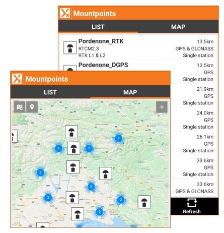
GNSS Mountpoints - Map & Distance
The list of the GNSS mountpoints has been redesigned and now offers an option to view the position of each mountpoint in the map and also to have the distance from them.
In this way the selection of the right mountpoint is much easier than before.
Changing Mountpoints in List and Map View
Watch this quick tutorial video to see how easy it is to view and change mountpoints in the list and map view.
X-PAD Ultimate - Made for Surveyors
GeoMax Positioning are committed to developing new features for X-PAD Ultimate that are designed to help Surveyors work more efficiently and precisely. With Service Pack Updates you get all the latest new features NOW including X-TILT, MountPoints and Stakeout, plus other important regular X-PAD updates throughout the year as soon as they are released.
X-PAD Ultimate is very easy to learn and all new features come with training resources and ongoing support from the BuildMax team!
New Feature: CAD Applications

CAD Edit polylines
CAD functions have been extended with some new options that allow users to edit the polylines. The new commands are:
- Open/Close polyline
- Add and remove vertices
- Remove segment
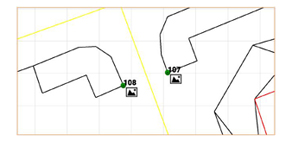
CAD Photo / sketch symbol
Topographic points that have an associated photo or a sketch are displayed with a specific symbol.
A long press on the point allows to open the dialogue with the photo/sketch.
CAD Snap Points
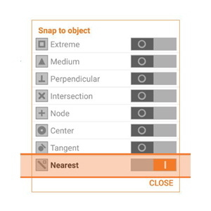
A new snap to object method has been added: NEAREST.Nearest snap mode allows to create points and other drawing elements on existing elements.
The insertion point of reference blocks can be used as “snap” point to create topographic points, to create drawings or as coordinate to stakeout.
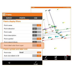
CAD Color of point labels
Labels of the topographic points can be displayed with the colour of the layer to which the point belongs to.
In this way the points can be recognised by their colours.
New Feature: Stakeout
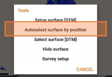
Automatic Surface Selection
X-PAD Ultimate is able to automatically select the surface to stakeout according to your position. So you don’t have to remember which is the right name of the surface but just because of your position the software selects the right surface for you.
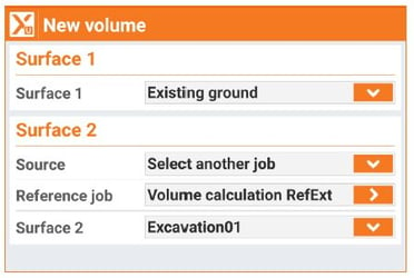
Volumes Surface Difference
Volumes can now be calculated by comparing two surfaces. Now you can compare a surface of the current job file with a surface that belongs to another job file. This makes the calculation by surfaces difference evenmore flexible because it can be immediately used in all cases in which surfaces are stored in different job files.
New Feature: COGO
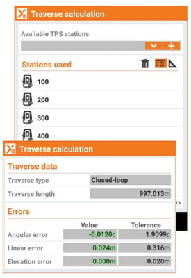
Traverse Calculation
In specific surveying activities it is required to set up a traverse that will be used to measure points with accuracy but also to be used as reference for following activities on the same sites.
It is then important to be able to estimate the quality of the traverse in the field, before coming back to the office.
X-PAD Ultimate introduces the Traverse calculation feature that analyses the measurements, identifies the traverse type (closed, closed-loop or open) and calculates the errors (linear and angular). Errors can be distributed along the traverse and the measured points can be recalculated.
Find Out More Here
Service Pack Updates deliver all the latest new features plus regular ongoing updates!

.jpg?width=300&height=250&name=BM%20Point%20by%20rule%20300%20x%20250-Medium-Quality%20(1).jpg)


